This is a very interesting application of data. And BTW, Where's George sounds like fun.
http://www.npr.org/blogs/krulwich/2013/04/16/177512687/a-whom-do-you-hang-with-map-of-america?utm_source=NPR&utm_medium=facebook&utm_campaign=20130417
Wednesday, April 24, 2013
Kessler GIS News: April 22, 2013
|
||||||||||
|
Monday, April 22, 2013
"Coincidentally" the Geodatabase, Part 1
"Coincidentally"
Over the years, I've noticed that many people have yet to explore the power of an ArcGIS geodatabase. What I mean is that some users are still strong-arming their way with shapefiles (sigh) because they are comfortable with them or are simply loading their data into a geodatabase as a feature class. COME ON! Geodatabases have been around since about 2001. It's time to capitalize on that powerful tool you have with ArcGIS.
The plan
This series of blogs is going to focus on feature coincidence. To get there will take a number of weeks of blogs to fully post this series. Here's my plan:
Part 1 -- introduce the feature dataset and how to add your shapefiles
Part 2 -- introduce topology and two very useful rules: Must Not Overlap and Must Not Have Gaps
Part 3 -- introduce working with coincidence and Area Boundary Must Be Covered By Boundary Of
Part 4 -- editing Area Boundary Must Be Covered By Boundary Of errors
This information is taken in part from my ArcGIS Desktop: Geodatabase Power User class. For more in-depth detail, you can sign up for my class. More information at Web Classes.
Required software:
Standard or Advanced version of ArcGIS Desktop (it used to be called ArcEditor and ArcInfo) version 10.1. (Much of this can be done with older versions of the software. I cannot keep track of what all works and doesn't work with the older versions.) Since we will be building geodatabases in this series, Basic ArcGIS (ArcView) users don't have all the capabilities.Assumptions:
I assume you know what a feature class is. Also, how to make a geodatabase and some of the basic functionality of one. If not, the ArcGIS Desktop: Managing Data class is a great way to get all the foundations about geodatabases and editing and managing feature data. Again, more information about my classes can be found at Web Classes.
The Feature Dataset (FD):
- Is a collection of feature classes (GirdD FD contains two)
- Is the environment for spatial reference
- Is the environment for topology (GirdD FD contains one)
- Is the environment for coincident geometry (topologic rules)
- Feature classes stored within an FD inherit it's spatial reference properties
- Feature data loaded into an FD can be projected on the fly
The FD can be interpreted as the “container” for feature classes. Benefit can be reaped from having a spatial reference defined for the FD so when new feature classes are loaded into an existing FD, the data will “project on the fly” (if necessary) into the spatial reference of the FD.
Creating a Feature Dataset:
Creating a feature dataset is quite easy. Using ArcCatalog or the Catalog Window in ArcMap, simply right-click on your geodatabase and choose New > Feature Dataset...
There are some properties you will need to set when creating one: name, coordinate systems, and tolerance. I'm assuming you know how to work with feature classes, so I won't go through coordinate systems or tolerance as these are basic pieces of knowledge for feature classes. If you are unsure of these properties, now is the time to make certain you know exactly what is going on. These properties will affect the outcome of all feature classes within your FD.
Importing and Projecting Feature Data:
You now have a template (your FD) for importing shapefile or other feature data. Right-click on the FD and choose Import > Feature Class (single)... or Import > Feature Class (multiple)...
Simply use the tool to browse to and choose your shapefile. By the way, it is VERY easy to import 10, 20 or 100 shapefiles this way.
You may choose a shapefile that is in the same coordinate system as your FD. It imports easily and quickly. You may also choose a shapefile that is NOT in the same coordinate system as your FD. In this case, it will project 'on the fly' as long as your input shapefile's coordinate system is correctly defined. If you are working with different datum's I suggest projecting/transforming your shapefile before importing so you can easily keep track of all the properties.
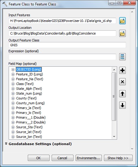
Here's the Feature Class to Feature Class tool populated with my example shapefile.
The result:
So there you have it! A shapefile loaded into a feature dataset.
In Part 2, I'll introduce topology and two very useful rules: Must Not Overlap and Must Not Have Gaps. I'll actually be using two real-world examples of parcels and zoning.
As always, I appreciate your comments, suggestions, and even spelling correcetions!
Until then... Happy Geodatabasing!
.jpg)
Friday, April 19, 2013
Ten quick checks to turn good maps into great maps
I found this short blog posted by exprodat GIS and thought it well done. Enjoy!
Ten Checks
#10 is good... to a limit. A north arrow can also confuse or mislead depending on the projection used. For instance, when using a polar projection, a north arrow would look just weird. And when using an Albers projection for the whole North American continent, north is quite variable. The north arrow would only be relevant at one longitude. Certainly, many users are smart enough to figure this out... but, well, you get my drift.
Wednesday, April 10, 2013
Education/Training as it relates to "Killing Employee Morale"
I was browsing through the LinkedIn group Learning, Education and Training Professionals Group a while back and ran across this article: "12 Most Lethal Ways to Kill Employee Morale".
I really appreciated the first item this author listed. "Offering Poor Training" The author, Doug Rice, combines this with another management mistake in assigning blame in the wrong place. When employees make a technical mistake, who's fault is it?
I would like to expound just a bit on this and say poor morale and poor performance can sometimes be directly linked to poor education and training. GIS is a very fast-moving industry and many people are not keeping up with progress. Organizations often see the demos by vendors and suffer from the "Bright, Shiny Object Syndrome" (BSOS). They may have heard the statement "This will save you money!" They buy the software and then do what? Well, here's a few things that can happen, but certainly there are other scenarios.
a) Management assigns the new software to a person who in the past has done good work (but also has their full load to complete). They buy a self-paced book and send them off to learn on their own. Now I could go into all sorts of detail here, but my belief is that self-paced learning only works for (my guess here) 15% of the people. Additionally, many only pick out the simplest way to get the job done and this method may simply chew up loads of time as it is very inefficient! I provide self-paced learning options, but I support students by answering questions as they progress through the materials. I don't totally let people go off on their own (unless they really want to). I do check back from time-to-time to see how they are doing as students can fall into a defeatism thought process if they struggle with anything.
b) Management sends the person to one class, thinking that the "Introduction" is good enough, then the person can self-learn from there on. This works for the highly motivated person, but again, self-directed advanced learning only happens with 15% of your employees (again, my guess).
c) Management sends one person to "Introductory" training, then expects that person to return and teach the rest of the people needing this skill. I'd estimate a good technical person is typically sent, but chances are that person has little to no teaching skills. In addition to this person having no skills in this area, they may well transfer the new information incorrectly or there may be internal "baggage" that inhibits thorough transfer of knowledge. Something that I've seen that is very likely is that they transfer the information they've learned as "the way" to do a task. See a) above for inefficient methods. I believe it is self-defeating for an organization to send one person to training, have that person learn a simple but inefficient method (that could be replaced by a more advanced method given more education) then have that person teach 20 others the inefficient method. Now there are 21 people doing the inefficient method! Some employees figure out it's highly inefficient, but have no power to change the methodology. People get worn down by doing long, tedious, inefficient tasks. Additionally, I feel this second level of education does not encourage people to learn on their own, but makes them reliant upon the in-house person for answers. This then has it's own set of problems.
d) After basic training and education, management has no continuing education program. Remember, I said GIS is fast-moving? Employees will learn that they are falling behind. I see lots of organizations working with software versions that are 3-5 years out-of-date! They aren't upgrading for one reason or another. (That's a whole issue that I could write pages on...) Does it help morale for users to see others with the latest/greatest and realize they are slogging along in the dark ages?
e) Management starts out with great intentions with a full education and support program. Then tough times fall on them (perhaps simply the whole economy slowing down) and the first thing to cut is training and travel! I've heard many people grumble about this. Yes, it is understandable that organizations need to cut costs. And training is one place. But year after year of cutting the budget in this area simply kills morale. Have you ever wondered why some good talent seek out other jobs? Maybe something as simple as not keeping up with the industry is one factor.
f) One item Doug brings up in the article is "Tolerating Bad Attitudes". Where did that attitude come from? Does skill and education feed into that? (Of course this sounds self-serving, but it could be as simple as the person not having a the proper education in using their tools -- GIS.) It is the managers job to figure this out and find a solution.
g) Doug talks about "Making extra-curricular work mandatory". I see many people in my classes who have traveled on Sunday with NO PAY just to attend the class. Now there are all sorts of reasons this happens, but dammit! If they need this class for work and they are not getting paid for travel time, this WILL, over time, kill morale! It may even give them a darn good reason to jump jobs after they've been sent to an expensive class. Now the organization they left has lost a valuable resource (unless the organization really needed that person to leave and had no other way to get rid of him/her).
To close, I'd like to say that every time I go to a conference, every time I take a class (yes, I teach a lot, but take classes as well), and every time I've been supported in expanding my knowledge and learning new skills, I've been energized. I believe most people are this way. Think about how education/training contributes to your business. Not just technically, but morale-wise. People with high morale will have high production!
Take a class from Kessler GIS today! :-)
Thursday, April 4, 2013
Kessler GIS News with Latest Helpful Blogs
|
||||||||||||
|
Subscribe to:
Comments (Atom)


